

- KITCHEN &
LAUNDRY - HOME &
GARDEN - TECHNOLOGY
& GAMING - HEALTH BEAUTY
& FITNESS - OFFICE &
COMPUTERS - KIDS NURSERY
& TOYS - CARS DIY
& OUTDOORS - MENS
CLOTHING - WOMENS
CLOTHING - HOLIDAYS
& TRAVEL - EBAY LOCAL
DEALS
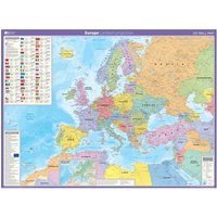
Map of Europe Poster | Laminated | Ordnance Survey Wall Map | Education Supplies | Geography | 123.5cm (w) x 91.2cm (h): Lambert projection (OS Wall Map)
Travel & Tourism
BEST OFFER
| BEST OFFER SUMMARY | |||
|---|---|---|---|
| Delivery: | FREE | Brand: | ORDNANCE SURVEY |
| Deal found: | Yesterday | EAN: | 9780319148457 |
| Checked: | 60 minutes ago | Status: | In Stock |
| Share deal: |


|
||
| Shop: | Promo: | Price checked: | Delivery: | Price: | Link: |
|---|---|---|---|---|---|
|
|
60 minutes ago | Free | £11.50 | Go to offer | |
| * Condition: New | |||||
|
|
19 hours ago | Free | £11.99 | Go to offer | |
| See website | --.-- | Check Site | |||
This wall map of Europe is shown in the Lambert Azimuthal equal area projection. This gives a map showing accurate sizes of countries, but with some distortion of the shapes. It shows international boundaries, major cities, towns, physical relief, key roads and rivers. It also has an inset with information on population, land area, currency, national flag, time zone and more. This map is gloss coated, so can be used with dry-wipe pens and is supplied flat and rolled in a cardboard storage tube. It's ideal for students, businesses or display. Size: 1,235mm X 912mmScale: 1:6 000 000 - Manufacturers part number: 3406
SIMILAR ITEMS:
Getting related products...