

- KITCHEN &
LAUNDRY - HOME &
GARDEN - TECHNOLOGY
& GAMING - HEALTH BEAUTY
& FITNESS - OFFICE &
COMPUTERS - KIDS NURSERY
& TOYS - CARS DIY
& OUTDOORS - MENS
CLOTHING - WOMENS
CLOTHING - HOLIDAYS
& TRAVEL - EBAY LOCAL
DEALS
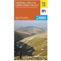
Howgill Fells & Upper Eden Valley Map | Yorkshire Dales National Park | Ordnance Survey | OS Explorer Map OL19 | England | Walks | Hiking | Maps | Adventure
Travel Atlases & Maps
| BEST OFFER SUMMARY | |||
|---|---|---|---|
| Delivery: | Unknown | Brand: | ORDNANCE SURVEY |
| Deal found: | 2+ weeks ago | EAN: | 9780319263341 |
| Checked: | 23 hours ago | Status: | In Stock |
| Share deal: |


|
||
| Email alert: | |||
| Price History: (901 days) | N/A | Low: High: | £5.40 £6.50 |
| Shop: | Promo: | Price checked: | Delivery: | Price: | Link: |
|---|---|---|---|---|---|
|
|
23 hours ago | See website | £6.50Unknown P&P | Go to offer | |
|
|
60 minutes ago | Free | £8.99 | Go to offer | |
| * Eligible for Prime | |||||
|
|
60 minutes ago | Free | £11.26 | Go to offer | |
| * Condition: New | |||||
|
|
18 hours ago | Free | £12.99 | Go to offer | |
Map Sheet OL19 in the Explorer Series covers Appleby-in—Westmorland, Sedbergh, Kirkby Stephen, and of course Howgill Fells and Uper Eden Valley.It is everything you need for exploring this beautiful area of barrow like hills, situated between the Lake District and the Yorkshire Dales. The Howgill Fells contain two Marilyns and five Hewitts, plenty of distance to cover for any keen hikers.Our Explorer maps are perfect for day-tripping, extensive hikes, and cycling they come in both standard and Weatherproof Active, so you'll never get caught out in a storm. This map also comes with a free digital download, so you can access it across your devices, making for a convenient companion. Publication Date: 01/10/2016 - Manufacturers part numbers: part_0319263347|4432
SIMILAR ITEMS: