

- KITCHEN &
LAUNDRY - HOME &
GARDEN - TECHNOLOGY
& GAMING - HEALTH BEAUTY
& FITNESS - OFFICE &
COMPUTERS - KIDS NURSERY
& TOYS - CARS DIY
& OUTDOORS - MENS
CLOTHING - WOMENS
CLOTHING - HOLIDAYS
& TRAVEL - EBAY LOCAL
DEALS
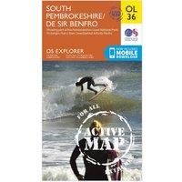
Ordnance Survey Explorer Active OL 36 South Pembrokeshire Map, Orange
Christmas Gifts
BEST OFFER
| BEST OFFER SUMMARY | ||||
|---|---|---|---|---|
| Delivery: | FREE | Brand: | ORDNANCE SURVEY | |
| Deal found: | Today | EAN: | 9780319469545 | |
| Checked: | 60 minutes ago | Status: | In Stock | |
| Share deal: |


|
|||
| FEATURES | ||||
Size: One Size Colour: Black | ||||
| Shop: | Promo: | Price checked: | Delivery: | Price: | Link: |
|---|---|---|---|---|---|
|
|
60 minutes ago | Free | £13.39 | Go to offer | |
| * Eligible for Prime | |||||
|
|
2 hours ago | Free | £16.99 | Go to offer | |
| See website | --.-- | Check Site | |||
The essential map for outdoor activities in all weathers in South Pembrokeshire. The OS Explorer Active Map is the Ordnance Survey's most detailed folding map and is recommended for anyone enjoying outdoor activities including walking, horse riding and off-road cycling. This map now comes with a digital version which you can download to your smartphone or tablet.FeaturesPembrokeshire CPKnights' WayDaugleddau TrailLandsker Borderlands TrailSouth of the LandskerPembrokeshire Coast Path (National Trail)Haverfordwest/HwlfforddJohnstoneMilford Haven/AberdaugleddauTenby/Dinbych-y-pysgodPembrokeshire Coast National ParkDyfed1:25 000 scale (4 cm to 1 km ' 2.5 inches to 1 mile) - Manufacturers part numbers: 26706111|4362
SIMILAR ITEMS:
Getting related products...