

- KITCHEN &
LAUNDRY - HOME &
GARDEN - TECHNOLOGY
& GAMING - HEALTH BEAUTY
& FITNESS - OFFICE &
COMPUTERS - KIDS NURSERY
& TOYS - CARS DIY
& OUTDOORS - MENS
CLOTHING - WOMENS
CLOTHING - HOLIDAYS
& TRAVEL - EBAY LOCAL
DEALS
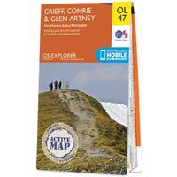
Ordnance Survey Active Explorer OL 47 Crieff, Comrie & Glen Artney Map, Orange/D
Maps & Atlases
| BEST OFFER SUMMARY | ||||
|---|---|---|---|---|
| Delivery: | Unknown | Brand: | ORDNANCE SURVEY | |
| Deal found: | 2+ weeks ago | EAN: | 9780319469651 | |
| Checked: | 3 hours ago | Status: | In Stock | |
| Share deal: |


|
|||
| Email alert: | ||||
| Price History: (887 days) | N/A | Low: High: | £8.50TODAY! £9.60 | |
| FEATURES | ||||
Size: One Size Colour: Black | ||||
| Shop: | Promo: | Price checked: | Delivery: | Price: | Link: |
|---|---|---|---|---|---|
|
|
3 hours ago | See website | £6.80Unknown P&P | Go to offer | |
| * Use voucher code BANK20 for this price | |||||
|
|
60 minutes ago | Free | £13.39 | Go to offer | |
| * Eligible for Prime | |||||
|
|
60 minutes ago | Free | £14.69 | Go to offer | |
| * Condition: New | |||||
|
|
3 hours ago | Free | £16.99 | Go to offer | |
The Active Explorer OL 47 is a detailed weatherproof map which covers Crieff, Comrie and the surrounding areas including the beautiful town of Auchterarder. A replacement for the previous OS Explorer map 368 for this area, the OL 47 allows you to navigate your way around the eastern part of the Loch Lomond & The Trossachs National Park and even covers two Munros: Ben Vorlich and Stuc a'Chroin.FeaturesDetailed and informative explorer map of Crieff, Comrie & Glen Artney from Ordnance SurveyCovers the Loch Lomond & The Trossachs National Park, Loch Earn, River Earn, Loch Turret Reservoir, Ben Vorlich and Stuc a'ChroinScale: 1:25000Now includes Mobile DownloadActive weatherproof versionRecommended activity - walking / hiking / cycling / naviga... - Manufacturers part number: 4306
SIMILAR ITEMS: