

- KITCHEN &
LAUNDRY - HOME &
GARDEN - TECHNOLOGY
& GAMING - HEALTH BEAUTY
& FITNESS - OFFICE &
COMPUTERS - KIDS NURSERY
& TOYS - CARS DIY
& OUTDOORS - MENS
CLOTHING - WOMENS
CLOTHING - HOLIDAYS
& TRAVEL - EBAY LOCAL
DEALS
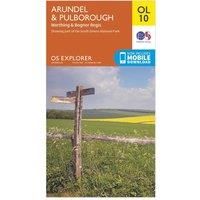
Ordnance Survey Explorer OL 10 Arundel & Pulborough Map, D/D
Maps & Atlases
BEST OFFER
| BEST OFFER SUMMARY | ||||
|---|---|---|---|---|
| Delivery: | Unknown | Brand: | ORDNANCE SURVEY | |
| Deal found: | 2+ weeks ago | EAN: | 9780319242490 | |
| Checked: | 9 hours ago | Status: | In Stock | |
| Share deal: |


|
|||
| Email alert: | ||||
| Price History: (250 days) | N/A | Low: High: | £7.80TODAY! £7.80 | |
| FEATURES | ||||
Size: 076 Colour: n/a | ||||
A replacement for the OS Explorer 121, the Explorer OL 10 from Ordnance Survey covers the South Downs National Park, the beautiful town of Arundel and the stunning coastline between Bognor Regis and Worthing. The River Arun is a prominent feature on this map which passes Pulborough and Arundel as it makes its way through the South Downs National Park to the English Channel.FeaturesDetailed and informative explorer map of Arundel & Pulborough from Ordnance SurveyCovers the town of Arundel, the River Arun, Monarch's Way and part of the South Downs WayScale: 1:25000Now includes Mobile DownloadRecommended activity - walking / hiking / cycling / navigation / expedition - Manufacturers part numbers: 15894255|42422432
- New Store Stock
SIMILAR ITEMS:
Getting related products...