

- KITCHEN &
LAUNDRY - HOME &
GARDEN - TECHNOLOGY
& GAMING - HEALTH BEAUTY
& FITNESS - OFFICE &
COMPUTERS - KIDS NURSERY
& TOYS - CARS DIY
& OUTDOORS - MENS
CLOTHING - WOMENS
CLOTHING - HOLIDAYS
& TRAVEL - EBAY LOCAL
DEALS
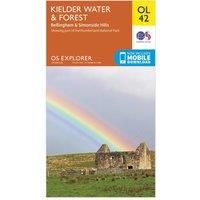
Ordnance Survey Explorer OL 42 Kielder Water & Forest Map, Orange
Maps & Atlases
BEST OFFER
| BEST OFFER SUMMARY | |||
|---|---|---|---|
| Delivery: | Unknown | Brand: | ORDNANCE SURVEY |
| Deal found: | 2+ weeks ago | EAN: | 9780319242810 |
| Checked: | 9 hours ago | Status: | In Stock |
| Share deal: |


|
||
| Email alert: | |||
| Price History: (250 days) | N/A | Low: High: | £7.80TODAY! £7.80 |
The essential map for outdoor activities in Kielder Water and Forest. The OS Explorer Map is the Ordnance Survey's most detailed folding map and is recommended for anyone enjoying outdoor activities including walking, horse riding and off-road cycling. This map now comes with a digital version which you can download to your smartphone or tablet.FeaturesPennine Way (National Trail)E2 (European Long Distance Route)BordersNorthumberland1:25 000 scale (4 cm to 1 km ' 2.5 inches to 1 mile)This map comes with a digital version which you can download to your smartphone or tablet. - Manufacturers part number: 15894319
SIMILAR ITEMS:
Getting related products...