

- KITCHEN &
LAUNDRY - HOME &
GARDEN - TECHNOLOGY
& GAMING - HEALTH BEAUTY
& FITNESS - OFFICE &
COMPUTERS - KIDS NURSERY
& TOYS - CARS DIY
& OUTDOORS - MENS
CLOTHING - WOMENS
CLOTHING - HOLIDAYS
& TRAVEL - EBAY LOCAL
DEALS
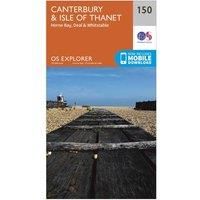
Ordnance Survey Explorer 150 Canterbury & Isle of Thanet Map With Digital Version, Orange
In-Car Entertainment
| BEST OFFER SUMMARY | |||
|---|---|---|---|
| Delivery: | Unknown | Brand: | ORDNANCE SURVEY |
| Deal found: | 2+ weeks ago | EAN: | 9780319243435 |
| Checked: | 14 hours ago | Status: | In Stock |
| Share deal: |


|
||
| Email alert: | |||
| Price History: (255 days) | N/A | Low: High: | £7.80TODAY! £7.80 |
The essential map for outdoor activities in Canterbury and Isle of Thanet. The OS Explorer Map is the Ordnance Survey's most detailed folding map and is recommended for anyone enjoying outdoor activities including walking, horse riding and off-road cycling. This map now comes with a digital version which you can download to your smartphone or tablet.Providing complete GB coverage, the OS Explorer map series details information essential in the great outdoors, including youth hostels, pubs and visitor information. Rights of way, fences, permissive paths and bridleways are clearly shown, ensuring you have the best information to get the most out of your time in the countryside.FeaturesNorth Downs WaySaxon Shore Way (Guide Book)White Cliffs Country TrailKCC Centenary Walk ' CanterburyWantsum WalkStour Valley WalkElham Valley Way (to be shown at 50k)Thanet Coastal Path (to be shown at 50k)E2 (European long distance route)North Downs Way (National Trail)KentCanterburyMargateRamsgate1:25 000... - Manufacturers part number: 15894413
SIMILAR ITEMS: