

- KITCHEN &
LAUNDRY - HOME &
GARDEN - TECHNOLOGY
& GAMING - HEALTH BEAUTY
& FITNESS - OFFICE &
COMPUTERS - KIDS NURSERY
& TOYS - CARS DIY
& OUTDOORS - MENS
CLOTHING - WOMENS
CLOTHING - HOLIDAYS
& TRAVEL - EBAY LOCAL
DEALS
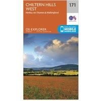
Ordnance Survey Explorer 171 Chiltern Hills West, Henley-on-Thames & Wallingford Map With Digital Version, Orange
Christmas Gifts
£7.51
Get offer| BEST OFFER SUMMARY | |||
|---|---|---|---|
| Delivery: | FREE | Brand: | ORDNANCE SURVEY |
| Deal found: | Today | EAN: | 9780319243640 |
| Checked: | 1 minute ago | Status: | In Stock |
| Share deal: |


|
||
| Shop: | Promo: | Price checked: | Delivery: | Price: | Link: |
|---|---|---|---|---|---|
|
|
1 minute ago | Free | £7.51 | Get offer | |
| * Like New | |||||
|
|
18 hours ago | See website | £7.80Unknown P&P | Get offer | |
| See website | --.-- | Check Site | |||
The essential map for outdoor activities in Chiltern Hills West, Henley-on-Thames and Wallingford. The OS Explorer Map is the Ordnance Survey's most detailed folding map and is recommended for anyone enjoying outdoor activities including walking, horse riding and off-road cycling. This map now comes with a digital version which you can download to your smartphone or tablet.Providing complete GB coverage, the OS Explorer map series details information essential in the great outdoors, including youth hostels, pubs and visitor information. Rights of way, fences, permissive paths and bridleways are clearly shown, ensuring you have the best information to get the most out of your time in the countryside.FeaturesRidgeway Oxfordshire Way Swan's WayBerkshire Circular Routes Bledlow Circular Ride Chiltern WayE2 (European Long Distance Route) Ridgeway (National Trail)Thames Path (National Trail) Oxfordshire BuckinghamshireBerkshireHenley-on-Thames1:25 000 scale (4 cm to 1 km ' 2.5 inches to 1 m... - Manufacturers part number: 15894439
SIMILAR ITEMS: