

- KITCHEN &
LAUNDRY - HOME &
GARDEN - TECHNOLOGY
& GAMING - HEALTH BEAUTY
& FITNESS - OFFICE &
COMPUTERS - KIDS NURSERY
& TOYS - CARS DIY
& OUTDOORS - MENS
CLOTHING - WOMENS
CLOTHING - HOLIDAYS
& TRAVEL - EBAY LOCAL
DEALS
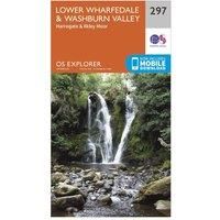
Ordnance Survey Explorer 297 Lower Wharfedale & Washburn Valley Map With Digital Version, Orange
In-Car Entertainment
| BEST OFFER SUMMARY | |||
|---|---|---|---|
| Delivery: | Unknown | Brand: | ORDNANCE SURVEY |
| Deal found: | 2+ weeks ago | EAN: | 9780319245491 |
| Checked: | 10 hours ago | Status: | In Stock |
| Share deal: |


|
||
| Email alert: | |||
| Price History: (253 days) | N/A | Low: High: | £7.80TODAY! £7.80 |
The essential map for outdoor activities in Lower Wharfedale and Washburn Valley. The OS Explorer Map is the Ordnance Survey's most detailed folding map and is recommended for anyone enjoying outdoor activities including walking, horse riding and off-road cycling. This map now comes with a digital version which you can download to your smartphone or tablet.Providing complete GB coverage, the OS Explorer map series details information essential in the great outdoors, including youth hostels, pubs and visitor information. Rights of way, fences, permissive paths and bridleways are clearly shown, ensuring you have the best information to get the most out of your time in the countryside.FeaturesDales WayDales Way (Guide Book)Dales Way LinkEbor WayLeeds Country Way Nidderdale WayWorth Way (West Yorkshire) Harrogate Ringway Knaresborough Round Millennium WayNorth Yorkshire West Yorkshire Bingley Harrogate Keighley1:25 000 scale (4 cm to 1 km ' 2.5 inches to 1 mile)This map comes with a digi... - Manufacturers part numbers: 15894629|43117556
SIMILAR ITEMS: