

- KITCHEN &
LAUNDRY - HOME &
GARDEN - TECHNOLOGY
& GAMING - HEALTH BEAUTY
& FITNESS - OFFICE &
COMPUTERS - KIDS NURSERY
& TOYS - CARS DIY
& OUTDOORS - MENS
CLOTHING - WOMENS
CLOTHING - HOLIDAYS
& TRAVEL - EBAY LOCAL
DEALS
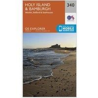
Holy Island and Bamburgh Explorer Map 340 Ordnance Survey
Maps & Atlases
BEST OFFER
| BEST OFFER SUMMARY | |||
|---|---|---|---|
| Delivery: | Unknown | Brand: | ORDNANCE SURVEY |
| Deal found: | 2+ weeks ago | EAN: | 9780319245927 |
| Checked: | 14 minutes ago | Status: | In Stock |
| Share deal: |


|
||
| Email alert: | |||
| Price History: (256 days) | N/A | Low: High: | £7.80TODAY! £7.80 |
| Shop: | Promo: | Price checked: | Delivery: | Price: | Link: |
|---|---|---|---|---|---|
|
|
14 minutes ago | See website | £7.80Unknown P&P | Get offer | |
| See website | --.-- | Check Site | |||
| See website | --.-- | Check Site |
Map sheet 340 in the OS Explorer series covers the Northumbrian coast from High Newton to Scremerston. An area with stunning views, forests and steeped in history. Highlights of the area include: Holy Island (Lindisfarne), The Farne Islands, Wooler, Bamburgh Castle, Seahouses and St. Oswald's Way.With this map you will receive a code for use on your iOS or Android smartphone or tablet. Find our more at Mobile Download FAQ. The OS Explorer map for Holy Island & Bamburgh is available in both the standard paper version and weatherproof 'Active' version. - Manufacturers part number: 15894572
SIMILAR ITEMS:
Getting related products...