

- KITCHEN &
LAUNDRY - HOME &
GARDEN - TECHNOLOGY
& GAMING - HEALTH BEAUTY
& FITNESS - OFFICE &
COMPUTERS - KIDS NURSERY
& TOYS - CARS DIY
& OUTDOORS - MENS
CLOTHING - WOMENS
CLOTHING - HOLIDAYS
& TRAVEL - EBAY LOCAL
DEALS
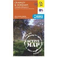
Ordnance Survey Explorer OL 34 Active D Crawley & Horsham Map, Orange/D
Non-Fiction
| BEST OFFER SUMMARY | |||
|---|---|---|---|
| Delivery: | Unknown | Brand: | ORDNANCE SURVEY |
| Deal found: | 2+ weeks ago | EAN: | 9780319469521 |
| Checked: | 7 hours ago | Status: | In Stock |
| Share deal: |


|
||
| Email alert: | |||
| Price History: (256 days) | N/A | Low: High: | £10.20TODAY! £10.20 |
Map sheet number OL 34 in the detailed OS Explorer Map series covers Horsham, Cranleigh, Crawley and Billinghurst. The new replacement for the OS Explorer map 134 for this area, highlights of the OL 34 map include the River Ouse, River Arun and River Adur, and corners of the Sussex Downs and South Downs.FeaturesDetailed and easy to read map from Ordnance SurveyScale: 1:25,000Covers Horsham, Cranleigh, Billinghurst, Low Weald, the western area of High Weald, the River Ouse, River Arun and River AdurIncludes mobile download of map for use on your smartphoneShows tourist information points, popular sites, viewpoints, places of information and rights of way informationRecommended activity - navigation - Manufacturers part numbers: 15956572|unknown
SIMILAR ITEMS: