

- KITCHEN &
LAUNDRY - HOME &
GARDEN - TECHNOLOGY
& GAMING - HEALTH BEAUTY
& FITNESS - OFFICE &
COMPUTERS - KIDS NURSERY
& TOYS - CARS DIY
& OUTDOORS - MENS
CLOTHING - WOMENS
CLOTHING - HOLIDAYS
& TRAVEL - EBAY LOCAL
DEALS
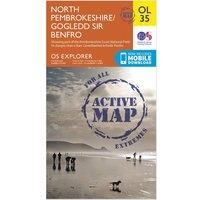
Ordnance Survey Explorer Active OL35 North Pembrokeshire Map, Orange/D
Maps & Atlases
BEST OFFER
| BEST OFFER SUMMARY | ||||
|---|---|---|---|---|
| Delivery: | Unknown | Brand: | ORDNANCE SURVEY | |
| Deal found: | 2+ weeks ago | EAN: | 9780319469538 | |
| Checked: | 7 hours ago | Status: | In Stock | |
| Share deal: |


|
|||
| Email alert: | ||||
| Price History: (256 days) | N/A | Low: High: | £10.20TODAY! £10.20 | |
| FEATURES | ||||
Colour: Black | ||||
| Shop: | Promo: | Price checked: | Delivery: | Price: | Link: |
|---|---|---|---|---|---|
|
|
7 hours ago | See website | £10.20Unknown P&P | Get offer | |
|
|
1 minute ago | See website | £15.20Unknown P&P | Get offer | |
| See website | --.-- | Check Site |
The essential map for outdoor activities in all weathers in North Pembrokeshire. The OS Explorer Active Map is the Ordnance Survey's most detailed folding map and is recommended for anyone enjoying outdoor activities including walking, horse riding and off-road cycling. This map now comes with a digital version which you can download to your smartphone or tablet.FeaturesPembrokeshire CPLandsker Borderlands TrailPembrokeshire Coast Path (National Trail) Cardigan/AberteifiFishguard/AbergwaunSt David'sDyfedPembrokeshire Coast National Park1:25 000 scale (4 cm to 1 km ' 2.5 inches to 1 mile)Â This map comes with a digital version which you can download to your smartphone or tablet. - Manufacturers part numbers: 15894301|42422997
SIMILAR ITEMS:
Getting related products...