

- KITCHEN &
LAUNDRY - HOME &
GARDEN - TECHNOLOGY
& GAMING - HEALTH BEAUTY
& FITNESS - OFFICE &
COMPUTERS - KIDS NURSERY
& TOYS - CARS DIY
& OUTDOORS - MENS
CLOTHING - WOMENS
CLOTHING - HOLIDAYS
& TRAVEL - EBAY LOCAL
DEALS
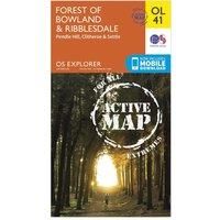
Ordnance Survey Explorer OL 41 Active D Forest of Bowland Map, D/D
Non-Fiction
| BEST OFFER SUMMARY | |||
|---|---|---|---|
| Delivery: | Unknown | Brand: | ORDNANCE SURVEY |
| Deal found: | 2+ weeks ago | EAN: | 9780319469590 |
| Checked: | 6 hours ago | Status: | In Stock |
| Share deal: |


|
||
| Email alert: | |||
| Price History: (255 days) | N/A | Low: High: | £10.20TODAY! £10.20 |
| Shop: | Promo: | Price checked: | Delivery: | Price: | Link: |
|---|---|---|---|---|---|
|
|
6 hours ago | See website | £10.20Unknown P&P | Get offer | |
|
|
1 minute ago | Free | £14.74 | Get offer | |
| * Condition: New | |||||
| See website | --.-- | Check Site | |||
Map sheet number OL 41 in the detailed OS Explorer Map series covers the Forest of Bowland and Yorkshire Dales National Park near Clitheroe. Highlights of the area include the towns of Clitheroe, Settle and Lancaster, and the Ribble Way, Wyre Way, Lune Valley Ramble and Pendle Way.FeaturesDetailed and easy to read map from Ordnance SurveyScale: 1:25,000Covers the Forest of Bowland, Yorkshire Dales National Park, Clitheroe, Settle, Lancaster, Ribble Way, Wyre Way, Lune Valley Ramble and Pendle WayIncludes mobile download of map for use on your smartphoneShows tourist information points, popular sites, viewpoints, places of information and rights of way informationRecommended activity - navigation - Manufacturers part number: 15894313
SIMILAR ITEMS: