

- KITCHEN &
LAUNDRY - HOME &
GARDEN - TECHNOLOGY
& GAMING - HEALTH BEAUTY
& FITNESS - OFFICE &
COMPUTERS - KIDS NURSERY
& TOYS - CARS DIY
& OUTDOORS - MENS
CLOTHING - WOMENS
CLOTHING - HOLIDAYS
& TRAVEL - EBAY LOCAL
DEALS
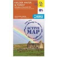
Kielder Water & Forest Map | Weatherproof | Bellingham & Simonside Hills | Ordnance Survey | OS Explorer Active Map OL42 | England | Walks | Hiking | Maps | Adventure (OS Explorer Map Active)
Handheld GPS Maps
| BEST OFFER SUMMARY | |||
|---|---|---|---|
| Delivery: | Unknown | Brand: | ORDNANCE SURVEY |
| Deal found: | 2+ weeks ago | EAN: | 9780319469606 |
| Checked: | 6 hours ago | Status: | In Stock |
| Share deal: |


|
||
| Email alert: | |||
| Price History: (255 days) | N/A | Low: High: | £10.20TODAY! £10.20 |
| Shop: | Promo: | Price checked: | Delivery: | Price: | Link: |
|---|---|---|---|---|---|
|
|
6 hours ago | See website | £10.20Unknown P&P | Get offer | |
|
|
1 minute ago | Free | £14.65 | Get offer | |
| * Condition: New | |||||
| See website | --.-- | Check Site | |||
The OS Explorer map of Kielder Water & Forest, including Bellingham and Simonside Hills. This map is a must-have when visiting the area, it covers an area of Northumberland National Park, stretching from Kielder Forest in the West to Netherwitton in the east, and takes in the town of Bellingham. Other features of this map include Bloody Bush & Larriston Fells Walk around Kielder water, The Pennine way National Trail, and St Oswald's Way.Our Explorer maps are perfect for day-tripping, extensive hikes, and cycling. They come in both standard and Weatherproof Active — so you'll never get caught out in a storm. This map also comes with a free digital download, so you can access it across your devices, making for a convenient companion. Publication Date: 10/06/2015 - Manufacturers part number: 15894314
SIMILAR ITEMS: