

- KITCHEN &
LAUNDRY - HOME &
GARDEN - TECHNOLOGY
& GAMING - HEALTH BEAUTY
& FITNESS - OFFICE &
COMPUTERS - KIDS NURSERY
& TOYS - CARS DIY
& OUTDOORS - MENS
CLOTHING - WOMENS
CLOTHING - HOLIDAYS
& TRAVEL - EBAY LOCAL
DEALS
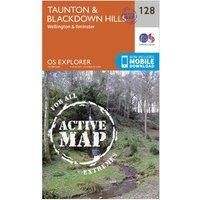
Ordnance Survey Explorer Active 128 Taunton & Blackdown Hills Map With Digital Version, Orange
Christmas Gifts
| BEST OFFER SUMMARY | |||
|---|---|---|---|
| Delivery: | Unknown | Brand: | ORDNANCE SURVEY |
| Deal found: | 2+ weeks ago | EAN: | 9780319470039 |
| Checked: | 10 hours ago | Status: | In Stock |
| Share deal: |


|
||
| Email alert: | |||
| Price History: (255 days) | N/A | Low: High: | £10.20TODAY! £10.20 |
| Shop: | Promo: | Price checked: | Delivery: | Price: | Link: |
|---|---|---|---|---|---|
|
|
10 hours ago | See website | £10.20Unknown P&P | Get offer | |
|
|
1 minute ago | Free | £14.65 | Get offer | |
| * Condition: New | |||||
| See website | --.-- | Check Site | |||
The essential map for outdoor activities in all weathers in Taunton and Blackdown Hills. The OS Explorer Active Map is the Ordnance Survey's most detailed folding map and is recommended for anyone enjoying outdoor activities including walking, horse riding and off-road cycling. This map now comes with a digital version which you can download to your smartphone or tablet.Providing complete GB coverage, the OS Explorer map series details information essential in the great outdoors, including youth hostels, pubs and visitor information. Rights of way, fences, permissive paths and bridleways are clearly shown, ensuring you have the best information to get the most out of your time in the countryside.Customers can now discover the landscape in all weathers thanks to the OS Explorer Map ' Active; a tough, versatile and wipe-clean version of the OS Explorer map.FeaturesRiver Parrett TrailGrand Western Canal TowpathWest Deane WayMacmillan Way WestSomersetDevonTaunton1:25 000 scale (4 cm to 1... - Manufacturers part number: 15956700
SIMILAR ITEMS: