

- KITCHEN &
LAUNDRY - HOME &
GARDEN - TECHNOLOGY
& GAMING - HEALTH BEAUTY
& FITNESS - OFFICE &
COMPUTERS - KIDS NURSERY
& TOYS - CARS DIY
& OUTDOORS - MENS
CLOTHING - WOMENS
CLOTHING - HOLIDAYS
& TRAVEL - EBAY LOCAL
DEALS
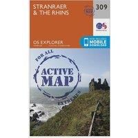
Ordnance Survey Explorer Active 309 Stranraer & The Rhins Map With Digital Version, Orange
In-Car Entertainment
| BEST OFFER SUMMARY | |||
|---|---|---|---|
| Delivery: | Unknown | Brand: | ORDNANCE SURVEY |
| Deal found: | 2+ weeks ago | EAN: | 9780319471814 |
| Checked: | 5 hours ago | Status: | In Stock |
| Share deal: |


|
||
| Email alert: | |||
| Price History: (254 days) | N/A | Low: High: | £10.20TODAY! £10.20 |
The essential map for outdoor activities in all weathers in Stranraer and The Rhins. The OS Explorer Active Map is the Ordnance Survey's most detailed folding map and is recommended for anyone enjoying outdoor activities including walking, horse riding and off-road cycling. This map now comes with a digital version which you can download to your smartphone or tablet.Providing complete GB coverage, the OS Explorer map series details information essential in the great outdoors, including youth hostels, pubs and visitor information. Rights of way, fences, permissive paths and bridleways are clearly shown, ensuring you have the best information to get the most out of your time in the countryside.Customers can now discover the landscape in all weathers thanks to the OS Explorer Map ' Active; a tough, versatile and wipe-clean version of the OS Explorer map.FeaturesE2 (European long distance route)Southern Upland Way (long distance route)StrathclydeDumfries and GallowayStranraer1:25 000 scal... - Manufacturers part number: 15994227
SIMILAR ITEMS: